The Joshua Plan
A Neurodivergent Man Drafts a Solution to the Israel-Palestine Conflict

This is a snippet from my book. This is during day 9 of Birthright 2040
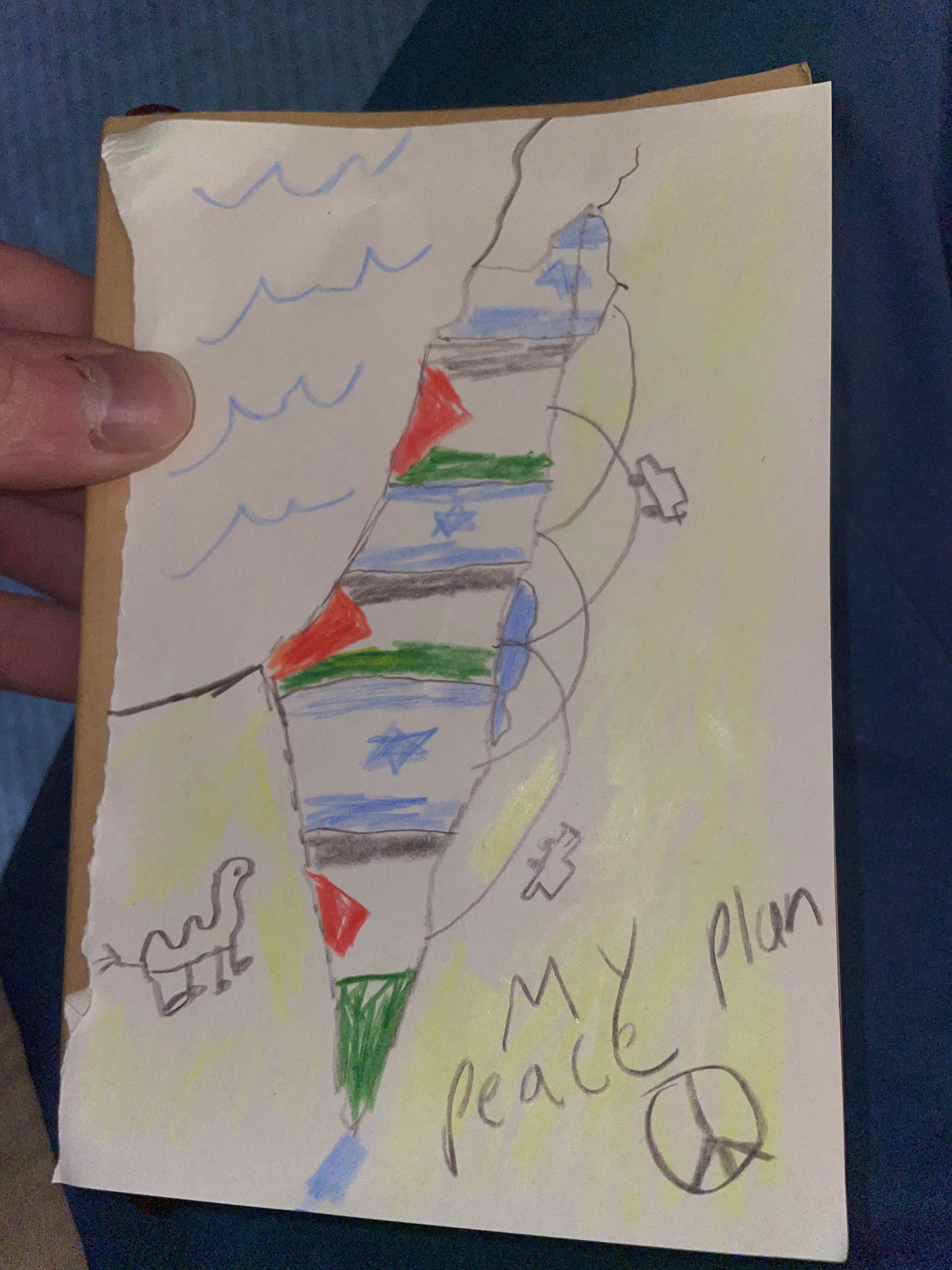
In a juvenile spiral-bound notebook, Joshua has sketched something that pours life into me. Joshua, a man who didn’t know there was a conflict until a few days ago, has drawn his own two-state solution.
The Joshua Plan divides the land from the river to the sea into six horizontal strips. Control alternates—Israeli, Palestinian, Israeli, and so on. Each side gets roughly equal territory, split into three noncontiguous enclaves. Or “exclaves,” if you want to pretend to be in one of the strips. I don’t. But perhaps this would appeal to Joshua.
At first, Joshua said, he thought Israel could just take the top half and the R.O.P. the bottom. But then—“like, why should one side just get, like, rocks and sand, ‘cause we’re in the bottom part now and it’s just that.”
Geographic variety trumps all. He drew it using a single topographic map, ignoring entirely where Arabs and Jews currently live.
Starting from the top (Israeli Strip 1, or I1): the tip of the Galilee Panhandle, down to just below Haifa.
Despite the Arab-populated Upper Galilee, it’s hard to argue it shouldn’t fall under Jewish rule, since it contains two of the four holy cities—Tsfat and Tiberias.
Palestinian Strip 1, or P1: just below Haifa down to just below Qalqilya.
The Jews lose Netanya, the coastal plain, and the Beit She’an Valley—but the Arabs make the stronger case, constituting a clear demographic majority. Their village clusters dominate the Lower Galilee, and their cities span the Samarian highlands and the Triangle: Jenin, Nablus, Umm al-Fahm (sorry again, al-Safiri).
They also get Nazareth for Christian tourism.
(Technically, Qalqilya and Tulkarm are in neither the Samarian highlands nor the Triangle. One could call them Green Line Lowlands.)
Joshua’s really lucking out so far—not just on who controls each strip, but where the strips end. Both cut off neatly right after major population centers.
Israeli Strip 2, or I2: from just above Tel Aviv to just below Jerusalem.
The Jews get their technological, financial, cultural, military, population, government, and religious capitals.
The Arab case for this strip barely exists—aside from some noise about Ramallah and Jericho.
The prayers for return to Ariel have been answered.
Palestinian Strip 2, or P2: from above Bethlehem to above Be’er Sheva
The Arabs get Hebron, Gaza, and Bethlehem—making it two for two on Christian historical cities.
Is the slight curve in the bottom edge of the strip the result of him holding the crayon with his fist, or did he actually mean to arc Rafah in and then rise to clear Be’er Sheva?
It has to be a coincidence, right?
Each band so far gives the respective group a demographic majority. He’s four for four!
If the first strip’s line had dipped just slightly lower, it would’ve flipped to an Arab majority—but no. God, or the ghost of Perlman, is guiding his hand.
Israeli Strip 3, or I3: from Be’er Sheva to Mitzpe Ramon.
The Jews get both of their major Negev settlements, the southern basin of the Dead Sea, and Dimona—where, in the 1950s, they built the only “textile plant” in history that required airspace restrictions and a security perimeter visible from orbit.
Sorry, Bedouins—you stood no chance. Live under Jewish rule or roam somewhere else.
Palestinian Strip 3, or P3: the ice cream cone tip.
As a consolation prize for losing Jerusalem, the Arabs are granted exclusive access to the Red Sea.
Finally, the Maghreb and the Mashreq are connected—a hinge between both sides of the Arab world.
Dividing the land into six horizontal, noncontiguous bands is absurd for so many reasons. But within that absurd framework, he’s done the best job one could do. Let’s get the Madrid 1991 Peace Conference back together. Give them the assignment: divide the land optimally into six alternating bands. I don’t think they could outperform Joshua. How did he eyeball this from a topographic map?
But Sasha is unimpressed. The facial slack is gone. He sneers at Joshua’s outlandish methodology.
“Saul, this is Rich!
Joshua, enlighten us. You—fresh from brokering Oslo—how does one travel between the states in your federation? Zipline? Please, walk us through it.”
“There’s really no need to mock him. I think he’s done a great job. His outsider way of thinking is refreshing—he’s shattered the paradigm.
Joshua, don’t let him intimidate you. Just answer him. Draw where the highways would go to connect the enclaves—that part can be just as fun as designing the alternating strips.
You’re only working off a topographic map. A road map would be more useful for this task. Look—here, we can pull one up on my phone. Our bus is on Highway 90 right now. That could be the spinal cord linking all three of your Israeli enclaves.”
Joshua considers it—but sketches a bolder solution. He might be the first avant-garde peacemaker. (Perlman was more of a modernist, still working within the traditional framework.) He doesn’t want to waste space in either of the new countries he’s drawn, so he places the connecting highways in the country to the left. A sideways “m” from I1 to I2 to I3. Another sideways “m” from P1 to P2 to P3.
“Yeah. That one’s called Jordan, Joshua.”
“Oh, like the shoe,” he says.
The idea for the interlocking loops came when his foot accidentally pressed his spiral notebook flat and he saw the spine.
I look down. He’s wearing Jordans.
The prophet Joshua will bring peace to the children of Isaac and Ishmael.
Once the loops are drawn, Sasha, delighted, snatches the map.
“I’m putting this on the fridge. Baby’s first peace plan. Joshua, my sweet, simple boy. I know he’s not like the other children, but he’s mine. Not a day goes by I don’t regret dropping him as a baby.”
Joshua tries his first justification.
“They’d agree to it... ‘cause of the tolls. The tolls in the other country. In that one. In Jordan. They’d get money from the other countries I made. Like, when people in the other countries drove on it.”
Sasha snatches the pen from Joshua’s hand. “I’m making some edits,” he announces.
“What if, instead of bands, it’s a checkerboard? Then at the corners, each group could slip through—no need for bloody highways in Jordan.”
He draws a line bisecting the map, Now the Arabs and Jews get six enclaves each.
“Stop mangling his work”
But my protesting only emboldens Sasha, who keeps dividing and dividing the land into smaller and smaller squares until you can’t even count the enclaves. He keeps going as I say stop—until there are no more boxes. The divisions are so small now, it’s just dots: blue for Jew, red for Arab. Village to village, a change in jurisdiction. Then, as he manically keeps poking at the map with the pens: house to house. Finally, person to person—until you can’t even see the separate dots anymore. Just one amalgamated purple. One state.
Joshua mourns his failed two-state solution, but not enough to do anything about it. He just stares out at the view Sasha was staring at. Different types of rocks pass by.
Sasha, unsettled by Joshua’s silent glare in the same direction, starts stabbing at the map until it tears—ink bleeding through to the next page: a journal entry by Joshua, now soaked in the entrails of Arabs and Jews.
Looking forward to riding a camel. Scared cuz Trevor said horses are scary and you need to know how to hold on in a good way so you don’t fall off it. When Trevor wasn’t dead he said that to me about it.
“Okayyy! We’re here, everyone—who’s ready for the Dead Sea? It’s salty, it’s sacred, it’s the lowest point on the whole planet! And it’s gonna sting if you’re like Saul and have been picking your cuticles!”